Sabino Canyon is a popular recreational area for outdoor activities in the outskirts of Tucson. If Tucson keeps the current pace of expansion it looks like it will be in the center of Tucson metropolitan pretty soon. The parking lot is fairly full and the overflow parking lot is open as well although I didn't have to use it. The unseasonal warm weather might have had something to do with also.
 The main trails start at the sign behind the visitor center. Since I have been there few times this time I started walking on trail that parallels the Sabino Canyon upper road. Between half mile to a mile there is a cut off for bluff trail that follows a wash along the ledge of some cliff kind of rock formation. It was nice and shady and I did get to see the only flower that I noticed in the valley. What attracted me was the fact there was a grasshopper and a beetle both inside that flower probably chomping it away, but before I could get the camera ready the grasshopper was gone and the fact beetle did not take off probably means it was dead. This section of the trail would be very interesting when there is water running in the wash. The trail meanders around and there were quite a few spur trails, although it is hard to get lost I found myself going around until I encountered a Sabino Canyon Volunteer. Since I did not have any concrete plan he suggested I go up on the Telephone line trail via Telephone line link trail. I took up on his offer to tag along till we hit the Telephone link trail. He was very informative about the whole area and the volunteer opportunities that exists in that area and ecology of that area.
 After we shook hands I started climbing on the Telephone link trail. It climbs quite a bit in a short distance along a rocky terrain with some interesting rock formations. I kept thinking about my conversation with the volunteer - even though you might not encountered any wild life there is a good chance you were seen by a mountain lion, there are around eighty of them in that area. Although there has been no known case of mountain lion attacking humans there have been few cases where couple of them had to be put down for stalking humans. Although mountain lions are very territorial the amount of food available seems to make them make the adjustments along with the fact their habitat seems to be shrinking. He also pointed out his last sighting of mountain lion was pretty close to the start of the Telephone link trail around 4.30 in the evening. That made me determined to be back before that time especially considering the sunset occurs around 5 pm this time of the year. I took a pit stop half way through the trail to catch my breath and I got unnerved with the sound of crunching rocks. When I looked up and scanned I could see nothing and I continued on and very soon I saw couple of hikers up above couple of switch backs from me. Human presence can be very reassuring indeed. Telephone trail as a continuation of the link trail kind of levels off (gentle gradient as opposed to continuous climbing). Before long I caught up with the older couple who were in front of me and one of them had a hard time extracting a thorn that got embedded in his leg after a accidental encounter. Just a reminder to all of us to be conscientious of the nature of plants in the desert terrain. After a brief chat I moved on with the understanding they would catch up with me but after a bit and where the trail curved around I saw them heading back leaving me alone with mountain lions, rather thoughts of mountain lions.
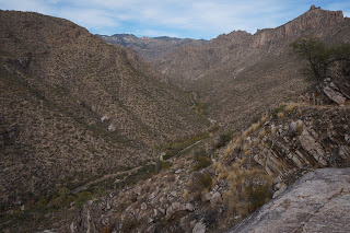
 It got very scenic as I moved along with the vistas opening up with the view of upper sabino canyon road winding through the canyon occasionally seeing a tram with visitors. Just when I was wondering when to turn around I saw two elderly ladies powering their way up the trail. Boy O Boy were they happy to see me and were escatic to learn the climb down the link trail was only a short distance away. They said I was the first one they encountered on their way which is not too surprising I guess considering the time of the time and the direction I was hiking. Soon afterwards i encountered a huge boulder that seems it is about to roll away but seems to have stayed as a picnic spot for hikers to enjoy the scene below. There are few helpful steps to climb to the top of flat top of that boulder. Top of that boulder one has a good view of a hill with kind of of thimble on top. One of the hikers I encountered told me the closer one gets to that one has a great view of sabino canyon, looking directly into it. Considering the time I ventured few minutes past this and it seemed the trail started climbing down and I was in no mood to climb back up so I started back.

Way back was bit more relaxing I was able to enjoy the view of lone saguaro on top of a rock where nothing should really be growing. It is amazing how the plants thrives with the slightest opportunity just a star reminder how much opportunity I squandered away being lazy or wanting to be given. When I got back to the junction of link trail i saw the sign with the option to continue towards the bear canyon and to be ended up near visitor center. So I continued on enjoying the view of Saguaros peppered all along. Most saguaros have the limbs growing up. Probably because i was not hurrying i noticed this freaky saguaro that had limbs downwards.
 I probably could have made it to the visitor center before 4.30 but considering the fact there were high clouds and a possibility of a very colorful sunset I dilly-dallyed along instead of dilly dillying for a budweiser. The juncture where the trail meets the sabino canyon dam one gets to see arizona fall colors. Some of the trees (don't know the name) had leaves with vivid colors surrounded by dry brushes. The real sad part was there is absolutely flowing anywhere in the park which is unusual. I remember Tucson had a good monsoon in terms of rainfall amounts (8.5" I believe). But it fell in very few but big storms and the water just ran off.
 Moral of the story to me was too much of a good thing (weather) is not necessarily a great thing.
Lot of birds eluded my photographing skills until this bird on top of a saguaro.
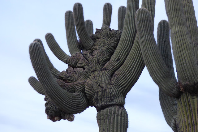
 It was amazing to see how it can be so comfortable on top of a saguaro tree amidst the thorns. I guess one can call that cactus yoga or something similar. Just to kill the time till sunset I went on the nature trail close to nature center. Very educational until i came across this emperor saguaro with the weirdest formation.
 The main trails start at the sign behind the visitor center. Since I have been there few times this time I started walking on trail that parallels the Sabino Canyon upper road. Between half mile to a mile there is a cut off for bluff trail that follows a wash along the ledge of some cliff kind of rock formation. It was nice and shady and I did get to see the only flower that I noticed in the valley. What attracted me was the fact there was a grasshopper and a beetle both inside that flower probably chomping it away, but before I could get the camera ready the grasshopper was gone and the fact beetle did not take off probably means it was dead. This section of the trail would be very interesting when there is water running in the wash. The trail meanders around and there were quite a few spur trails, although it is hard to get lost I found myself going around until I encountered a Sabino Canyon Volunteer. Since I did not have any concrete plan he suggested I go up on the Telephone line trail via Telephone line link trail. I took up on his offer to tag along till we hit the Telephone link trail. He was very informative about the whole area and the volunteer opportunities that exists in that area and ecology of that area.
 After we shook hands I started climbing on the Telephone link trail. It climbs quite a bit in a short distance along a rocky terrain with some interesting rock formations. I kept thinking about my conversation with the volunteer - even though you might not encountered any wild life there is a good chance you were seen by a mountain lion, there are around eighty of them in that area. Although there has been no known case of mountain lion attacking humans there have been few cases where couple of them had to be put down for stalking humans. Although mountain lions are very territorial the amount of food available seems to make them make the adjustments along with the fact their habitat seems to be shrinking. He also pointed out his last sighting of mountain lion was pretty close to the start of the Telephone link trail around 4.30 in the evening. That made me determined to be back before that time especially considering the sunset occurs around 5 pm this time of the year. I took a pit stop half way through the trail to catch my breath and I got unnerved with the sound of crunching rocks. When I looked up and scanned I could see nothing and I continued on and very soon I saw couple of hikers up above couple of switch backs from me. Human presence can be very reassuring indeed. Telephone trail as a continuation of the link trail kind of levels off (gentle gradient as opposed to continuous climbing). Before long I caught up with the older couple who were in front of me and one of them had a hard time extracting a thorn that got embedded in his leg after a accidental encounter. Just a reminder to all of us to be conscientious of the nature of plants in the desert terrain. After a brief chat I moved on with the understanding they would catch up with me but after a bit and where the trail curved around I saw them heading back leaving me alone with mountain lions, rather thoughts of mountain lions.
 It got very scenic as I moved along with the vistas opening up with the view of upper sabino canyon road winding through the canyon occasionally seeing a tram with visitors. Just when I was wondering when to turn around I saw two elderly ladies powering their way up the trail. Boy O Boy were they happy to see me and were escatic to learn the climb down the link trail was only a short distance away. They said I was the first one they encountered on their way which is not too surprising I guess considering the time of the time and the direction I was hiking. Soon afterwards i encountered a huge boulder that seems it is about to roll away but seems to have stayed as a picnic spot for hikers to enjoy the scene below. There are few helpful steps to climb to the top of flat top of that boulder. Top of that boulder one has a good view of a hill with kind of of thimble on top. One of the hikers I encountered told me the closer one gets to that one has a great view of sabino canyon, looking directly into it. Considering the time I ventured few minutes past this and it seemed the trail started climbing down and I was in no mood to climb back up so I started back.


Lot of birds eluded my photographing skills until this bird on top of a saguaro.
 It was amazing to see how it can be so comfortable on top of a saguaro tree amidst the thorns. I guess one can call that cactus yoga or something similar. Just to kill the time till sunset I went on the nature trail close to nature center. Very educational until i came across this emperor saguaro with the weirdest formation.


