Saturday, February 24, 2018

Salton Sea


More Photos

Introduction 

On my road trips from Los Angeles to Tucson usually I end up breaking the journey in Indio, CA, and visit spotlight casino. After a meal and gambling 20 dollars away I hop onto I-10 and drive into what seems like a never ending dessert. As I-10 climbs from 14 ft below sea level in Indio to 1700 feet at Chiriaco Summit it is usual to get stuck behind a truck struggling to pass another truck with blinkers on which in turn is struggling to climb the hill.  Not sure if it was loosing more money than usual in Spotlight Casino or the boredom with the all too familiarity of the route that spurred me to take highway 111 and take a break near the Salton Sea Visitor center which is just a short distance from the town of Mecca.

The first thing I noticed after getting out of my car was the terrible stench and I have a very poor sense of smell. The ladies who pulled into the parking lot after me were surprised by the stench as well as evident by their comments.  However, the vista of vast body of water, almost 340 square miles or so, in the middle of a dessert with a slim shore line, with Pelicans and hardly any people in sight was a reward in itself.
As I walked towards the shoreline the sand seemed very coarse and make a peculiar crunchy sound. A closer examination of the "sand" revealed I was actual stepping on the dried carcasses of the fish and the entire shoreline seemed like a open graveyard of fishes. Quite a few theories went through my mind none of which were even closer to the truth. Apparently millions of fish die every summer, mainly Tilapia, due to depletion of dissolved oxygen in these waters and gets  washed ashore.  The raise and fall Salton Sea seems to resemble the tragedy of these fishes.

SALTON SEA OVERVIEW 

This seemingly desolate area sitting on top of San Andraes fault with intriguing names of surrounding towns like Macca, Bombay Beach etc has not only interesting geological history but also a unique history of human settlement and is a object of number of documentaries that can be found of youtube.  Here are some interesting facts :
  •  But for the delta created by Colorado river,  salton sea would have been part of the ocean instead of being a lake. Some people in the neighboring town of Indio would have had ocean front properties. 
  • The max depth of salton sea is around 42 feet
  •  For the thousands of years before the taming of Colorado river this area has alternated between a fresh water lake, saline lake and a dry dessert depending on the moods of the Colorado river. 
  • Current formation of the Salton sea was due to a engineering accident while trying to increase the water flow into this area that caused constant flow of water for almost two years from Colorado river. 
  • This area was also used by military for various research projects (including atomic bomb research) before abandonment. 
  • 1950s and 1960s  saw the peak visitor usage of Salton sea area rivaling that of Yosemite.
  • 7.6 million fish deaths in a single day was recorded in August 1999 
  • Close to 9000 pelicans died of avian botulism in 1996 in this area.   
Apparently fish die off every summer is due to depletion of dissolved oxygen in the lake. Oxygen depletion is a common phenomenon not unique to this area. The extreme heat of 110 plus degree weather in this area for the most part of summer along with high winds cause severe oxygen depletion leading to very high number of fish dying. The decline of Salton Sea visitation for recreation coincided with the raise in salinity of the lake and the fish kill among other factors.

BOMBAY BEACH 

Some of the beaches here are fee areas but Bombay beach is free and is like open museum containing relics that symbolize raise and fall of salton sea as a recreational area. Although this whole area is full of abandoned houses there are some people who actually live here.  The beach itself is full of relics from the past - abandoned boats, fallen apart pier and other structures that I have no idea about. This time I did not see any dead fishes but lots of birds and quite a
few visitors which was a bit surprising to me but there are plenty of birds who flock together at whatever the feather composition maybe. And beware! There are no public bathrooms here either.


 SONNY BONO WILDLIFE REFUGE


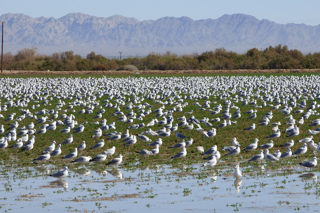
After feeling bit burnt after a visit to Leslies Canyon Wild Life Refuge when I saw signs for this refuge I was bit tentative and was in no mood to drive on a unpaved road again but decided to check this out anyway.  After driving for about five miles from Highway 111 turn off i was rewarded with a field on the side of the road filled with snow geese and a handful of birds whose name I have no idea of, some kind of crane I imagine. They were pretty patient with me walking around at the edge taking photos but very watchful. This encouraged me to continue on with the exploration to the visitor center.


View from Rock Hill
The visitor center is small but adequate with bathrooms and plenty of parking. There is a observation deck near the visitor center, but there was not much to observe from that vantage point. The bird viewing area is along the Rock hill trail, an easy one mile trail (one way).  It starts at the visitor center and ends on top of Rock Hill. Rock hill is one of the 5 small lava domes in Salton sink area, also known as Salton Buttes. Salton Buttes are the only active volcanoes in Southern California. The last recorded volcanic activity was around 900 B.C., way before the modern Salton sea was formed.

Just before the Rock hill there are few man-made islands meant as breeding grounds for some of these birds.  Top of the hill offers the vista of entire salton sea and an encounter with visitors who were gracious enough to share their knowledge of the birds.

UNIT - 1

This is the habitat for thousands of migratory birds and is 14 miles away from the visitor center. It is also easily accessible from highway 78 which runs parallel to the west shore of salton sea. It has a couple of observation decks and a photo blind. Coming from El Centro, CA, it would have made more sense for me to have visited this area first if I had known about it and then proceed to the visitor center. It has couple of observation decks few hundred feet apart.
Unfortunately, there was not much to be seen from these observation deck either and there was not much human activity here. Probably because of the time of the day.  One can see abundance and variety of birds in the neighboring fields. However, due to widespread nature of this area density of the bird population seemed bit sparse. The photo blind is located a short hike from the observation deck. There are different fields with different levels of water to accommodate
different species of wading birds. Around 2 PM when I was about to leave it was getting real toasty. Considering it was early Feb one can only imagine how brutal it could be few months from now. On my drive back I could see flocks of birds coming back and it probably is a great place to visit later in the afternoon.
Saturday, February 10, 2018

Yuma


MY MISCONCEPTIONS ABOUT YUMA 

Yuma was always my stop over during my trips from Tucson to Los Angeles. My impression of Yuma was that of a small town centered around a prison with over priced hotels and higher priced coffee in Starbucks compared to neighboring cities including Phoenix, AZ.  The rugged dessert surrounding this town with oppressive heat most of the year made sense for building of a prison. I would imagine no one in their right mind would want to escape into the neighboring desert or to neighboring mexico. But then one could argue people in prison are hardly in right frame of mind.  A visit to Yuma Crossing National Heritage area, and a e-visit to Yuma Chamber of Commerce helped shed some of my misconceptions. However, I am still at a loss to understand why the cost of coffee (2.15$ for small cup) in Starbucks here is higher than Tucson since the sales tax in Tucson is 8.6% as opposed to 8.41% in Yuma.  For now I am just going to attribute it to entertainment tax for listening to loud sales people making their sales on phone in that starbucks. This time since I had plenty of time I decided to stop and explore Yuma and enjoy its weather at this time of the year. No wonder tourism is the third biggest industry here mainly relying on snowbirds followed by agriculture (which was a big surprise to me) and military.

Yuma Crossings National Heritage Area

This was the spot for my daytime activity in Yuma, Buffalo Wild Wings being the spot for night time. This area as I later found out is actually divided into

  • Sunrise Point Park
  • Pivot Point Interpretive Plaza
  • Gateway Park
  • Riverside Park
  • East and West Wetlands
  • Historic Territorial Prison
On the main side road leading into this area there is a big traffic roundabout, which is huge, reminding me of the so called "traffic circles" in India while growing up which survived for a long time even in big cities like Bangalore. Depending on which exit you take you would end up in one of the above areas or on I : 10 to Tucson. 

Sunrise Point Park 

This is a very relaxing park right next to Mission Puerto De Purisima and Paradise Casino. There is no entry fee to the park but I put in a 20$ in Paradise Casino in one of the slot machines anyway. 

Mission Puerto De Purisima is a beautiful historical landmark building nestling on top of a small hill overlooking the Ocean to Ocean bridge and the historical territorial prison. On a sunny winter day it is a great place to relax and watch the trains crossing the bridge. 3:10 to Yuma may or may not be running but there is a train every 10 minutes or so it seems crossing the Ocean to Ocean bridge carrying lots of cargo. I also saw few homeless people cross the bridge and walk into the sunrise point park, not sure if they got off these trains or it was just a coincidence.

There is a small pond close to the entrance of this park where I saw few people fishing. I also saw an Eagle dive into the pond, apparently it was fishing as well not sure if it caught anything but it was fun to watch. This area is alive with bird activity but none of the cooperated to pose for my camera. There are few trails leading into the wetlands which I did not explore on this occasion. There are couple of historical remnants of Quechan tribe right next to the river.

Pivot Point Interpretive Plaza 

I ended up in this area only because I thought this was the main parking lot for Gateway Park. Having reached decided to explore it especially after seeing a 1907 Baldwin locomotive right next to parking lot. It is mind boggling to imagine this locomotive logged few million miles, at least two million if my memory serves right. There are panels on a sidewalk giving excellent introduction to the history of Yuma, the booming of this area because of California gold rush as this region offered the narrowest crossing of the colorado river at that time. I did not need a mirror to answer the question "mirror, mirror on the wall who is the misconceived of them all".  There is a stairway behind the locomotive that leads to the Gateway Park. 

Gateway Park/Riverside Park 


Gateway Park has a great view of the Ocean to Ocean bridge part of former US 80, especially around sunset, commemorates the first highway crossing of the lower colarado river.  The other side which is part of the Riverside park of this one can view love immortalized.  The bravery of these love birds to write their names on top of this bridge should put Romeo to shame. One can also view wading birds fishing in the river. There is a paved bike path and a trail that meanders parallel to the river. The trail is lined with trees and provides a welcome shade in summer.


I followed the trail till I hit the historic landmark "Emily & Luis" drawn on the side wall of canal.  One can only wonder, if the blackening of this original writing was the work of Veronica who always had a crush on Luis. There is always a third side to every love story.  Somewhere along the trail there is a branch off that leads to the base of historic territorial prison and it has nothing to do with any of the lover birds. Unlike Sunrise point Park this area seems more popular with the locals as well as visitors probably because of the rich local history. 

Historical Territorial Prison 

Like the slogan of democracy this prison was built by the prisoners for the prisoners to the prisoners. If they had any complaints about their cells at least the first six first ones who built it and imprisoned themselves they have no one but themselves to blame. In all honesty I visited it and went through the introductory panels but did not enter the fee area. The entry fee is 8$ which is not much. But it seemed bit strange to pay to see the symbolism of human mistakes. When I read the panel that described some of the prisoners who were Mormons men of character, but got imprisoned for having more than one wife and ended with the question "Did these men got imprisoned for their religious beliefs or crime on society" it became intriguing.  I compromised my dilemma by promising myself a serious inquiry into "crime and punishment" over a 8$ beer in Buffalo Wings and I kept the beer drinking part of the bargain.

Friday, January 5, 2018

Sivan Vahkih - Casa Grande Ruins

Sivan Vakih

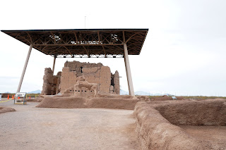
The primary motivation to visit this monument was not only to get the most bang for the buck out of National Park Pass but also to reply in affirmative to a good friend of mine, who always queried if I visited the Casa Grande Ruins whenever I told him I was in Casa Grande.  Incidentally Casa Grande Ruins is not located in the city of Casa Grande, AZ but Coolidge AZ a neighboring town.  Probably the fact city of Casa Grande which was founded in 1879 during the mining boom and Coolidge was founded later in 1924 explains how Coolidge ended up with the custody of the ruins.  While looking at the google maps I also saw a attraction called "Sivan Vahki".  Being of East Indian heritage the word Sivan which stands for the name of a Hindu God attracted my attention and decided the added attraction is worth the detour on my journey from Phoenix to Tucson. Upon reaching the destination after several changes of mind every time it sprinkled on this cold blustery day I realized Sivan Vahki is part of the National Monument and the words "Casa Grande" in spanish and "Sivan Vahki" in O'odham mean the same thing "Big House".  I also realized I had zoomed past this area quite a few times without realizing this was a archaeological site.

One enters this archaeological site through the visitor center after paying the requisite fee. There is a ranger lead tour every and a volunteer lead tour alternating every hour. As soon as I entered the exhibit hall mentally congratulating myself upon getting 5$ return upon my 80$ investment on the National Park Pass ( the fee is increased to 10$ in 2018 ) I was met with a Volunteer who introduced himself and explained the tour is about to start in few minutes and in all probability I would be the only one and if I preferred I can watch the video which is about to start soon and then take the tour the next hour which is what is recommended so one can appreciate the archaeological site and ask intelligent questions.

But I decided to do it the other way and the tour ended up being more personal one on one tour. The tour consists of a introduction to the Ancient Sonoran People and their way of life including their primitive tool set followed by a tour of the archaeological site.

Area surrounding Casa Grande Ruins
It is hard time for me who would have a miserable time spending a night without air conditioner, let alone a day, in this area to imagine ancient people choosing this area to settle down and flourish. Probably a testament to human endurance.  Upon watching the Video I realized  there was flowing water in this area at that time and the modern human settlement which necessitated the construction of diversions and flood control structures changed this terrain.  It was also interesting to note they dug irrigation canals spanning hundreds of miles using very primitive tools like sticks and cactus spines. To my great surprise I learned how tough a Saguaro Cactus spine is. Also considering its length they were also used as a tool to pick fruits from the tall saguaro trees. Interestingly the saguaro fruit also  referred to as "bahidaj" was not only used in food preparation but also to prepare intoxicating drinks. Fortunately or unfortunately no sample of that drink was available, maybe NPS should consider that to attract more visitors.  Saguaro spines were also used as calendar sticks with symbols of important events carved on it , Saguaro eMojis!!.

Sivan Vahki 


 The main attraction of this monument is the remnants of a four story house - Sivan Vahki, built out of natural concrete like material called "caliche". The significance of this house was not entirely clear, at least to me. There are three big holes on top of this structure and one of them coincides with the direction of sun on summer solstice.  One of the conjectures, as the volunteer told me, this was a multi use structure, abode of a priest, to note astronomical events of significance to their culture and probably a store house of seeds.  Currently for sure it is of significance to few owls who nest there, whose glimpse I did not catch. It probably was too cold for them to say hello to visitors that day.

Building housing structures using caliche was a gradual transition in dessert dwelling where in pit houses were the norm, interestingly something in common between Eskimos and dessert dwellers.  Caliche is supposed to become soft after a period of rain.  Probably it takes lot more than a few sprinkles of rain to have that effect. Must have been a big nightmare to manage kids a from poking holes in the houses during monsoon season.  I guess, the beauty of this housing is all one needs to fix leaks or cracks is some more caliche, pick up some caliche and plaster it.  Small footprint on the environment indeed!

There is also overlook next to parking lot which is supposed to be a platform where the ancient people played ball. One can only hope they fared better than the Arizona Cardinals and Phoenix suns, local football and basketball teams.

East Indian Connection 

Since I was familiar the usage of word "Siva" in the jewish culture I was intrigued by its reference in this context. However finding any link between the ancient East Indian Civilization and the ancient Sonoran people seemed far fetched to me, even under the influence of the intoxicating juice made out of Saguaro.  Imagine my surprise when I stumbled upon this website Ancient India's Emperor Priyavarta Invaded Arizona! where the author not only finds quite a few parallels between the words used by ancient sonoran people and Sanskrit a ancient east Indian language, but also corroborative stories between the two cultures. It is fascinating but I did not venture to verify the authenticity of the author. However, I did find a book ancient history of India which SEEMS authentic where there is a reference to similar story of one of the sons of Priyavarta invades a land whose describes is similar to America.

However far fetched the above theories might be one thing for sure, at least to my mind - all types of Indians considered land to be sacred and found god in all living creatures.

Wednesday, December 27, 2017

Ash Meadows Wildlife Refuge


GETTING THERE 


This wild life refuge is located close to Death Valley approximately couple of hours away from Las Vegas, NV. There are couple of alternate routes to get there. Google maps showed the route through Pahrump, NV was shorter by about 20 miles but would take the same amount of time as 93N through Indian Springs but suggested 93N. Although I was bit apprehensive about going through the downtown traffic and sphagetti bowl exchange it turned out to be route. Had better luck traversing the I-15 traffic than the slot machines and once I went past Santa Fe Station the traffic died down and near Indian Springs I had to look for traffic.  Between Indian springs and the turn off for 373 towards Armagosa valley there is just desert.  One is free to enjoy the freedom from stimulus of civilization or suffer the boredom and endured the pangs of hunger.  The big billboard "Hungry?" for the Area 51 Alien center seemed like a sign for heaven when I pulled over I saw a big store,  a diner and a brothel next to each other. I was hungry for food so i chose the diner. It was small with few empty tables and a bar with a couple sitting and a girl behind the counter busy texting. Between the time I sat down at the bar, went through the menu few times and left after few failed attempts to attract her attention she was still busy texting.  Later I mentally thanked her for saving some time for me to enjoy the park.


WILD LIFE REFUGE 

I took the spring meadows road a dirt road the main path way of the refuge . Soon after entering the refuge one sees a visitor information center which is just a big board with a detailed map and few information brochures. I thought this was it but then I saw the signs for the main visitor center. At this point I had few second thoughts about visiting this refuge which looked dry and barren with few rewards for a two hour drive.   On the way to visitor center I passed on few attractions since all of the dirt roads leading up to them had the sign saying "high clearance vehicle" recommended. Later the staff at the visitor center center said it was more for sports cars rather than sedans.  The visitor center is big with neat rest rooms and even "covered parking"! Might come very handy in summer.  Friendly staff, answered my questions patiently with recommendations and offered to queue up some informational videos for watching but I was running short of time.  Given I had only around 3 and half hours before sunset they recommended visiting crystal board walk, crystal reservoir, devils hole and point of rocks.  I remembered watching a TV report on Devils Hole and had mentally tossed it in and out of my bucket list since it is all fenced off and one cannot see the fish. When I mentioned it to staff they still said it is worth a visit.

Crystal Spring Board Walk 

The board walk i located right behind the visitor center and is a .9 mile leisurely walk with plenty of benches to rest and take it all in.  The initial part of board walk is over a dry land till it meets a gurgling stream at the far end. Later the staff explained to me the board walk is there not only to protect the habitat but also to protect the visitors shoes and the visitor centers since the land becomes real gooey even with a little rainfall. It is refreshing to see running water and spot birds surrounded by dry rugged terrain.

Crystal Reservoir

Contrary to my expectations for the crystal reservoir to be right next to the crystal board walk it is couple of miles away. It is amazing to see this vast body of water surrounded by hundreds of miles of dry dessert supporting plant and bird species and deepens the appreciation of the wild life refuge and the conservation effort at the surrounding land.  The land is quite gooey closer to water with quite a few ducks clustered here and there. I probably could have spotted few more birds near the marsh less than a mile away but I decided to give it a pass.

Devils Hole

Although in the vicinity of the wild life refuge it is actually part of the Death Valley National Park.  It is also well named since thats all we get to see here. Seems dry but it is fascinating to learn how the water in the hole we are  peering into is connected to the underground waters that are important to Nevada and California.  It is mind boggling to learn that a mini-tsunami was observed here as a result of an earthquake in Mexico.

The highly fenced off area surrounding this hole with a narrow passage leading up to a viewing area might lead one to imagine it as pupfish prison. However this is a desperate attempt to conserve this endangered species as detailed in this report 

This article in scientific american https://blogs.scientificamerican.com/running-ponies/the-plan-to-save-the-rarest-fish-in-the-world/
details the efforts and to save this rarest fish in the world.
There is a small path thats leads to another gridded hole where one can only peer into darkness and what one sees depends purely on ones imagination I guess.

Peering into this hole one does not see much but Devils hole seems to stand for the deepening divide between conservationists and developers and the awareness of which is key to the future of this planet or someones pocket maybe.

Point Of Rocks

This is probably my favorite spot in this refuge but I also spent the least amount of time due to the fact there is a big sign "The gate automatically closes at dusk" at the gate near the turnoff to this area on spring meadows road. I would have waited till sunset but I did not want to be stranded in this area however beautiful it might be. There is a short board walk surrounded by some greenery with plenty of benches and the angle of light at the sunset brings out colors in this rugged terrain along with the chirping birds. There is plenty of picnic areas near the parking lot indicating its popularity, however, at this time I was alone. As the sun neared the horizon I made a bee line to be out of the gated area and when I approached the gate I saw a sign that said "Gate opens automatically if closed, stop here to avoid damage".  I guess next time I would confirm with the visitor center about the reliability of opening and closing of these gates before staying there at dusk.

GETTING BACK 


 The spring meadows road leads to Bella Vista Road. There is a turn off leading to the left that requires a high clearance vehicles and it is easy to head in that direction in dark since it traverses a lot longer distance before meeting with Bella Vista Road. As I neared the Bella Vista Road I was rewarded with sunset colors all around.  This single lane highway leads Pahrump.
I made a mental note to stay at one of the hotels nearby next time around to enjoy a longer stay at the park as well as a possible visit to Death Valley. There was quite a bit more traffic on the way to Vegas from Pahrump and it is single lane most of the way.

Here is the link for additional photos.

Tuesday, December 12, 2017

Saguaro National Park East


Saguaro National Park is physically two different parks located on the opposite sides of Tucson, AZ.  Although both are within short driving distance from Tucson downtown, to me, the west side of the park is slightly more accessible since one does not have to drive all the way across the town. After I took the Valencia exit on I - 10 and stopped near the Jack in the box the google map went crazy asking me to go the opposite way on Valencia. Finally after I canceled the navigation and restarted it started giving the proper directions. Compared to most other National Parks this park seems to be low key including the street signs.  Before the pay station there is a big visitor center with a mid size parking lot. The visitor center staff are very friendly and eager to answer any questions. 
One of the new staff members enlightened me about the geology of the surrounding area and I was surprised to learn the Tucson desert is a very young dessert, only few tens of thousands years old.  I was not able to confirm that upon later research but then I could have misinterpreted what he meant.


Shortly after the pay station the road becomes a one way loop and it is little bit windy but not too bad, the only thing to bear in mind is occasional pedestrian or a jogger on the road.  There are few parking lots in the first few miles of the loop road for accessing the hiking trails.  Today I chose to do the Loma Verde loop which is probably close to 3.5 miles. It is very well marked and well maintained trail with minimal elevation gain a delight for a lazy hiker like myself.  There are plenty of saguaros peppered throughout the loop with limbs going every which way reminding me of what one of the staff members at the visitor center said jokingly "Saguaro National Park West has more number of saguaros but here on the east side we have saguaros that have more personality with more limbs going in all different directions.  He even showed me a picture of saguaro with prickly pear growing out of it.  Within the first half mile one can see a saguaro swooping down like a dinosaur with a little bit of imagination I guess.


This is a great trail to spot birds. It was a overcast day so it was a great day for hiking and not so great for photos still I was able to spot few different species of birds.  After hiking in the dessert a bit I have become familiar with Gila Woodpecker which seemed to be everywhere on the trail with occasional phainopepia. The rest of the birds I still need to learn the names.  I hardly met anyone on the trail, probably because it was a weekday. I tried to extend the loop by going on the monument wash and hooking up with Deer Valley wash trail which seemed like bit of a mistake since hiking in the sandy wash was bit difficult and hard on the ankles but still it was fun.  When I returned back to the the trailhead I did see few cars parked although I did not meet them on the trail probably because it is a loop trail.
On the way back I stopped by Javalina Rock which is a great place to enjoy the surrounding landscape as well as to enjoy the sunset. 


Thursday, November 30, 2017

Sabino Canyon - Telephone line trail

Sabino Canyon is a popular recreational area for outdoor activities in the outskirts of Tucson. If Tucson keeps the current pace of expansion it looks like it will be in the center of Tucson metropolitan pretty soon. The parking lot is fairly full and the overflow parking lot is open as well although I didn't have to use it.  The unseasonal warm weather might have had something to do with also. 

The main trails start at the sign behind the visitor center. Since I have been there few times this time I started walking on trail that parallels the Sabino Canyon upper road.  Between half mile to a mile there is a cut off for bluff trail that follows a wash along the ledge of some cliff kind of rock formation. It was nice and shady and I did get to see the only flower that I noticed in the valley. What attracted me was the fact there was a grasshopper and a beetle both inside that flower probably chomping it away, but before I could get the camera ready the grasshopper was gone and the fact beetle did not take off probably means it was dead. This section of the trail would be very interesting when there is water running in the wash. The trail meanders around and there were quite a few spur trails, although it is hard to get lost I found myself going around until I encountered a Sabino Canyon Volunteer. Since I did not have any concrete plan he suggested I go up on the Telephone line trail via Telephone line link trail. I took up on his offer to tag along till we hit the Telephone link trail. He was very informative about the whole area and the volunteer opportunities that exists in that area and ecology of that area.
After we shook hands I started climbing on the Telephone link trail. It climbs quite a bit in a short distance along a rocky terrain with some interesting rock formations. I kept thinking about my conversation with the volunteer - even though you might not encountered any wild life there is a good chance you were seen by a mountain lion, there are around eighty of them in that area. Although there has been no known case of mountain lion attacking humans there have been few cases where couple of them had to be put down for stalking humans.  Although mountain lions are very territorial the amount of food available seems to make them make the adjustments along with the fact their habitat seems to be shrinking.  He also pointed out his last sighting of mountain lion was pretty close to the start of the Telephone link trail around 4.30 in the evening.  That made me determined to be back before that time especially considering the sunset occurs around 5 pm this time of the year.  I took a pit stop half way through the trail to catch my breath and I got unnerved with the sound of crunching rocks. When I looked up and scanned I could see nothing and I continued on and very soon I saw couple of hikers up above couple of switch backs from me.  Human presence can be very reassuring indeed.   Telephone trail as a continuation of the link trail kind of levels off (gentle gradient as opposed to continuous climbing).  Before long I caught up with the older couple who were in front of me and one of them had a hard time extracting a thorn that got embedded in his leg after a accidental encounter. Just a reminder to all of us to be conscientious of the nature of plants in the desert terrain.  After a brief chat I moved on with the understanding they would catch up with me but after a bit and where the trail curved around I saw them heading back leaving me alone with mountain lions, rather thoughts of mountain lions.

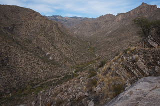
It got very scenic as I moved along with the vistas opening up with the view of upper sabino canyon road winding through the canyon occasionally seeing a tram with visitors. Just when I was wondering when to turn around I saw two elderly ladies powering their way up the trail. Boy O Boy were they happy to see me and were escatic to learn the climb down the link trail was only a short distance away.   They said I was the first one they encountered on their way which is not too surprising I guess considering the time of the time and the direction I was hiking. Soon afterwards i encountered a huge boulder that seems it is about to roll away but seems to have stayed as a picnic spot for hikers to enjoy the scene below. There are few helpful steps to climb to the top of flat top of that boulder.  Top of that boulder one has a good view of a hill with kind of of thimble on top. One of the hikers I encountered told me the closer one gets to that one has a great view of sabino canyon, looking directly into it.  Considering the time I ventured few minutes past this and it seemed the trail started climbing down and I was in no mood to climb back up so I started back.

 Way back was bit more relaxing I was able to enjoy the view of lone saguaro on top of a rock where nothing should really be growing. It is amazing how the plants thrives with the slightest opportunity just a star reminder how much opportunity I squandered away being lazy or wanting to be given.  When I got back to the junction of link trail i saw the sign with the option to continue towards the bear canyon and to be ended up near visitor center. So I continued on enjoying the view of Saguaros peppered all along. Most saguaros have the limbs growing up. Probably because i was not hurrying i noticed this freaky saguaro that had limbs downwards.

I probably could have made it to the visitor center before 4.30 but considering the fact there were high clouds and a possibility of a very colorful sunset I dilly-dallyed along instead of dilly dillying for a budweiser.  The juncture where the trail meets the sabino canyon dam one gets to see arizona fall colors. Some of the trees (don't know the name) had leaves with vivid colors surrounded by dry brushes.  The real sad part was there is absolutely flowing anywhere in the park which is unusual.  I remember Tucson had a good monsoon in terms of rainfall amounts (8.5" I believe).  But it fell in very few but big storms and the water just ran off. 
Moral of the story to me was too much of a good thing (weather) is not necessarily a great thing.

Lot of birds eluded my photographing skills until this bird on top of a saguaro.


It was amazing to see how it can be so comfortable on top of a saguaro tree amidst the thorns. I guess one can call that cactus yoga or something similar.  Just to kill the time till sunset I went on the nature trail close to nature center. Very educational until i came across this emperor saguaro with the weirdest formation.


Wednesday, November 22, 2017

Cave Creek Regional Park

CAVE CREEK REGIONAL PARK


Located within a short driving distance from phoenix near Happy Valley this beautiful desert park offers rugged views of Sonoran Desert. It has numerous trails for multi purpose usage for horseback riding, biking and hiking.  The best thing about these trails are most of them can be made into loops combining each other into a distance of one's liking or to test ones endurance. 

Coming from Las Vegas my aim was to visit the cave creek trail in Tonto National Forest. After considering the traveling distance and that one has to drive on a gravel road for 12 miles I decided to settle for this nice regional park and I was not disappointed. It offers a nice quite escape from the city life into well maintained and marked trail system. As of Nov 21, 2017 the entry fee was 6$ per vehicle and less for day usage by bicycle. Although it has plenty of benches spread throughout the park shades are hard to come by. The weather was perfect for hiking with the highs around 79 degrees reported in phoenix. Even in that perfect weather by 2 PM out in the desert floor I was feeling it out on the Go John trail in one particular section near the Gunsight pass where there was absolutely no shade for a while. I can only imagine how tough it would be out in hot days which seems to be most days of the year in this area. 

Nature center is located a short distance from the pay station and has coffee from Kurig coffee machine at $1.50 a cup and energy bars and water are for sale as well. The staff were extremely friendly and patient. They answered all my questions on their trail system along with recommendations.  They even had couple of rattlesnakes in the showcase and one of them was extremely big. I am afraid of snakes and an encounter with a big one like that in the wild I would want to turn around and run. But then if it is overweight and sluggish it may not be the worst to encounter as well. I was bit tentative watching out for the rattlers constantly when I started my hike but when I saw how well maintained the trails were with no overgrowth of the shrubs or grass onto the trail I relaxed. 

I started out on the Overton Trail with the intention of taking Maricopa Trail back to the nature center a 3 mile loop in time for a good lunch. When I reached the junction of Maricopa Trail I was feeling good although hungry and I couldnot resist but go along the Go John trail and complete the 6 mile loop. Overton Trail starts off with views of nearby town as it climbs and it stinks a bit of the horse dung. I guess the horses relieve themselves near the begining of the trail and I didn't see the dung droppings that much after a mile or so. The only wild life I encountered was some birds trying to peck away insects out of the horse dung.  I wanted to take some photographs of birds but waiting for a photo opp near that smell or the photo opp itself was not that apealing so I climbed on. Plenty of Saguaros spread throughout the park. 

Once the trail meets the maricopa trail it starts climbing down to the desert floor and I believe at its lowest point or so it reaches the park boundary. At this point there is a park bench where one can relax and enjoy the view. But the solitude was not so quite since there is a road construction going on with plenty of banging. That noise soon got engulfed in the silence of the desert floor after traversing half a mile. This stretch I believe would be real tiresome in the sun since there is absolutely no shade till it starts climbing back again.  Between the bench near park boundary and the Quartz trail it meets with a spur trail that has no name and it hard to get lost even if one tries. The trail starts climbing back again near the Gunsight pass and then starts climbing down near the Quartz trail.


 Even though the saguaros were sprinkled throughout the park there is one stretch I didn't see much of them but it was interesting to see one lone Saguaro on top of a hill. Before the Go John trail ends there is a sprinkling of variety of Saguaros new and old. Most them don't have branches or siblings as I like to think. The largest saguaro is supposed to be 10 feet in girth, that is simply amazing unless they count the width of the limbs. The largest saguaro recorded was in cave creek region (not sure here or in cave creek part of tonto national forest) but the height recorded was 78 feet (almost double what we see around here) before it was toppled in a storm. The one most limbs in this area is located closer to the end of Go John trail and I call it grand father saguaro. You get to to see some young not so tall but with many short limbs.  Go John trail ends pretty close to picnic area next to a huge parking area where you pick up the overton trail to continue on to nature center. It starts following the main road for a bit before forking off into a trail crossing a wash with a hop skip and jump to the nature center.

It took me close to 3.5 to 4 hours but i took plenty of breaks and I believe one can finish the trail within three hours.